


Via the Kaltenbachseen to the Deneck
Accessible by public transportCharacteristics
SkillThe tour in numbers
Level of difficulty
medium
Route
7,5 km
Time
5:30 h
Uphill
850 hm
Downhill
850 hm
Highest point
2433 m
Steep paths, beautiful lakes and a full-blooded peak – intermediate-level alpine tours don’t get any more fun than this.
This attractive mountain tour is also a highly recommended family hike, as it can also be done in stages.
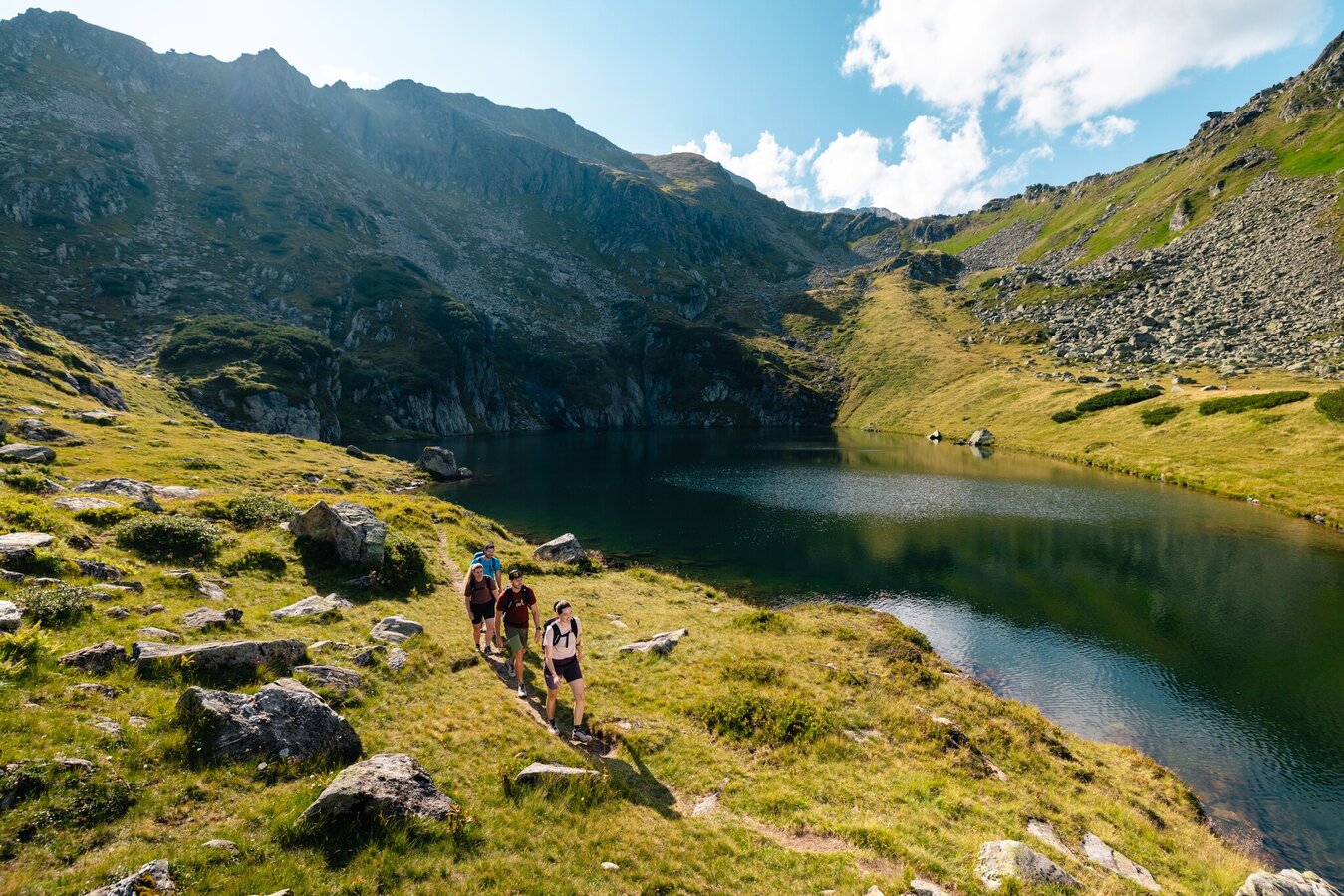
Above the Kaltenbachalm, at the sharp bend in the road, there is a small parking lot. From there, the trail leads over the stream and then in many serpentines up to the first Kaltenbachsee lake. Past the Lower Kaltenbachsee and on to the Middle Kaltenbachsee. Only slightly steeper uphill to the Upper Kaltenbachsee and over the Etrachboden and the Schafspitze to the Deneck. When the alpine roses are in bloom, the slopes are a sea of flowers, and the yellow gentian can also be found here.
Above the Kaltenbachalm, at the sharp bend in the road, there is a small parking lot. From there, the trail leads over the stream and then in many serpentines up to the first Kaltenbachsee lake. Past the Lower Kaltenbachsee and on to the Middle Kaltenbachsee. Only slightly steeper uphill to the Upper Kaltenbachsee and over the Etrachboden and the Schafspitze to the Deneck. When the alpine roses are in bloom, the slopes are a sea of flowers, and the yellow gentian can also be found here.
Best season
January
February
March
April
May
June
July
August
September
October
November
December
More information
Branch off from the Ennstalbundesstraße B320 at Pruggern to Sölktäler. From Stein an der Enns to the Großsölktal and further to St. Nikolai. From there across the Sölkpass to the Kaltenbach Alm.
From the Kaltenbachalm parking lot, you hike along serpentines to the first Kaltenbachsee lake and on to the middle Kaltenbachsee lake. Above the tree line, the trail leads over a long slope up to the Upper Kaltenbachsee. This lake already has a distinctly alpine character, but is a wonderful place to linger.
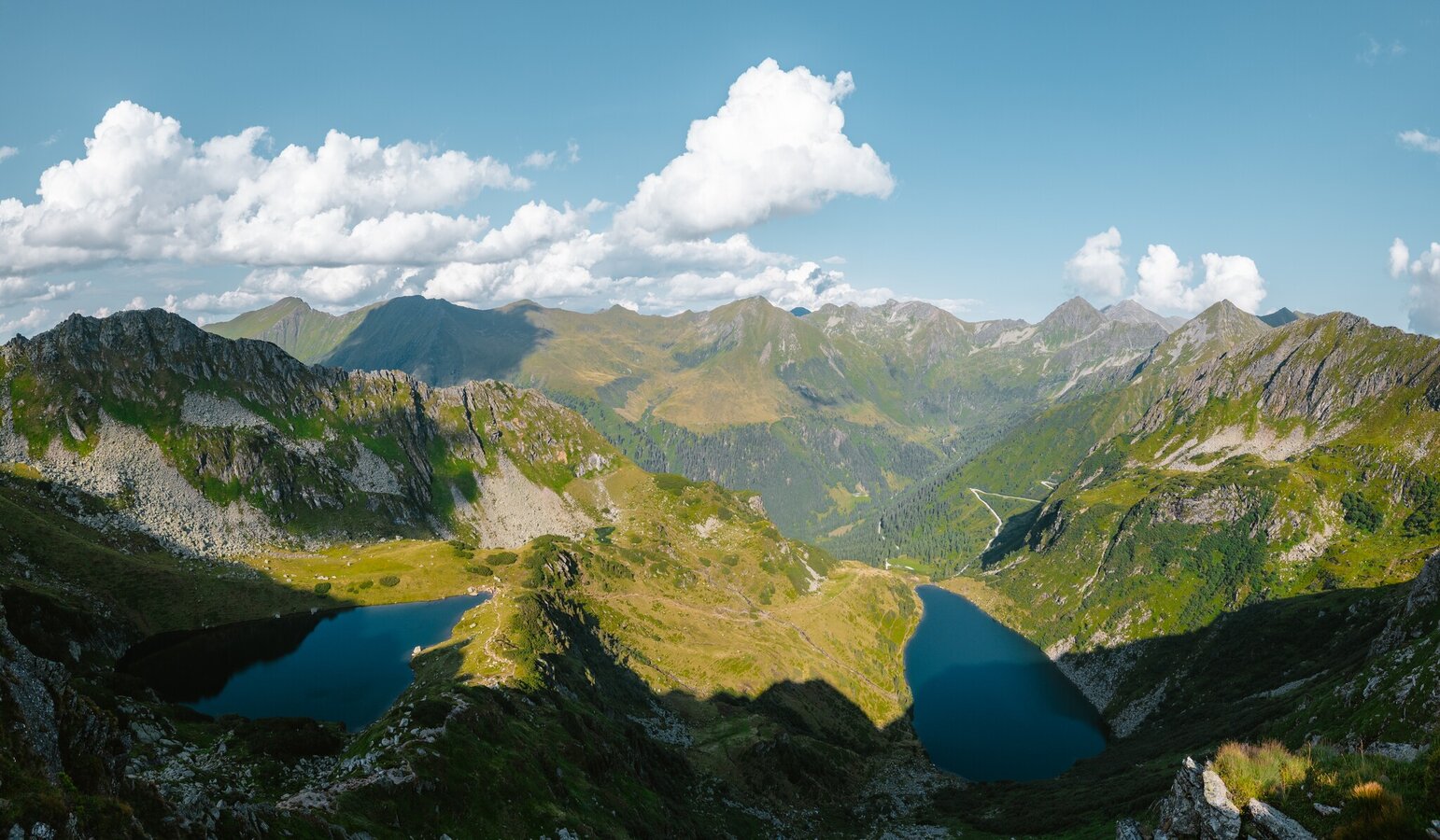
However, the next destinations are no less attractive: on the left bank, the trail climbs steeply over a rocky spur into a small cirque. A gushing stream is the next point of reference, as the trail leads over a short but steep rocky shoulder up to the Etrachböden. This is a gently structured, wide plateau with a magnificent panoramic view of the Tauern peaks. The view down to the lakes and the striking hairpin bends of the Sölkpass road is impressive and clearly shows the difference in altitude that has already been overcome. Up here, it's easy to keep up; small streams cut through the meadows, which are divided by gentle crests.
Summit conquerors follow the trail to the right-hand ridge, descend briefly into a depression, cross rugged terrain (marked) and ascend on the south-west side to the large summit cross.
Return along the same path. Sticks are certainly an advantage on this hike - be careful in wet conditions.
SummitLynx- Your digital summit and hut book - available worldwide and always with you!
Arrival at Stein/Enns train station with ÖBB.
Cab Stefan Mayer: +43 676 54 09 858
Valley bus from July 5 to September 7, 2025 - this makes crossings in the Sölktäler Nature Park possible. You can also travel comfortably by train and the valley bus will take you to the starting point of your hike. Click here for the timetable.
Cab Stefan Mayer: +43 676 54 09 858
Valley bus from July 5 to September 7, 2025 - this makes crossings in the Sölktäler Nature Park possible. You can also travel comfortably by train and the valley bus will take you to the starting point of your hike. Click here for the timetable.
Kaltenbach Alm
Mountain guides from the region: www.schladming-dachstein.at/mountainguides
For more information, please contact the Schladming Dachstein Tourist Office - Sölktäler Nature Park Information Center:
Phone: +43 3687 23310 501
mailto:info@schladming-dachstein.at
Stein an der Enns 107
8961 Sölk
The brochure “Schladming-Dachstein Hiking” is available in all information offices in the region.
Map & downloads
Gallery

Blick auf den Unteren Kaltenbachsee | © Gerhard Pilz | Gerhard Pilz
1/17

2025_wandern_deneck_016cmathaeus_gartner_27082025-27.jpg | Mathäus Gartner
2/17

2025_wandern_deneck_011cmathaeus_gartner_27082025-27.jpg | Mathäus Gartner
3/17
Mathäus Gartner
4/17
Mathäus Gartner
5/17

Deneck | © Fotograf: Volkhard Maier | Schladming Dachstein
6/17

Unterer Kaltenbachsee mit Blick zum Gipfel des Denecks | © Fotograf: Volkhard Maier | Schladming Dachstein
7/17

2025_wandern_deneck_058cmathaeus_gartner_27082025-27.jpg | Mathäus Gartner
8/17

Zwischen Unterem und Mittleren Kaltenbachsee | © Fotograf: Volkhard Maier | Schladming Dachstein
9/17

2025_wandern_deneck_052cmathaeus_gartner_27082025-27.jpg | Mathäus Gartner
10/17

Deneck 2.433m | © Fotograf: Volkhard Maier | Schladming Dachstein
11/17

Blick Richtung Knallstein | © Erlebnisregion Schladming-Dachstein | Christoph Lukas
12/17

Auf den Etrachböden angekommen | © Erlebnisregion Schladming-Dachstein | Christoph Lukas
13/17

Via Schafspitze hinauf zum Deneck | © Erlebnisregion Schladming-Dachstein | Christoph Lukas
14/17

Vom Gipfel des Deneck hinunter auf die Etrachböden | © Erlebnisregion Schladming-Dachstein | Christoph Lukas
15/17

Eine Wanderin auf den Etrachböden | © Gerhard Pilz | Gerhard Pilz
16/17

Bergerlebnis auf der Tour zum Deneck | © Gerhard Pilz | Gerhard Pilz
17/17
What the weather will be like Sölk (668m)
Forecast
06.09.2025

8°C
22°C
07.09.2025
8°C
25°C
08.09.2025

10°C
24°C
